

In today’s world of architecture and construction, Building Information Modeling (BIM) tools like Revit have revolutionised the design and construction process
3D Site Models in Revit format
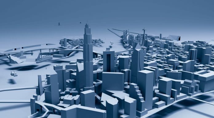
AccuCities adds RVT format to its list of standard delivery formats for its 3D city maps and 3D site models which currently includes AutoCad solid format, FBX format, widely used to transfer 3D models between software packages such as 3D Studio Max or AutoDesk Maya, and the SketchUp format, commonly used in architectural studios.
Revit’s collaborative features facilitate interdisciplinary collaboration among architects, urban planners, engineers, and other professionals, leading to more integrated and well-coordinated designs. AccuCities 3D city models can now be used in Revit directly, giving our architectural customers a streamlined way to incorporate into their design geospatial information, including neighbouring context buildings and features, terrain height and land use data and other environmental factors.
Urban site environments in Revit
By including detailed information about the land, nearby buildings, and landscaping, designers can create more realistic and accurate plans. This helps in spotting potential issues early on, like how the slope of the land might affect the building’s foundation or drainage system. Catching these issues early can save a lot of time and money. AccuCities provides highly detailed 3D city models in Revit format, ensuring that these visualisations are as accurate and comprehensive as possible.
Using a 3D site model in Revit allows for a thorough analysis of the site and its environmental factors. For example, designers can see how sunlight, wind, and the shape of the land will affect the project. This helps in making decisions that optimise building placement and energy use, and ensure compliance with environmental regulations.
AccuCities 3D models are especially useful here, as they provide high-resolution data on urban environments. This data is crucial for analysing how new buildings will interact with existing structures and the natural environment, helping to create more sustainable and resilient designs.
Accurate and detailed 3D site models in Revit support detailed site and environmental analysis, and streamline construction planning and management. By using these models, professionals can deliver projects that are more efficient, cost-effective, and environmentally friendly.
Free 3D London in Revit sample
Free 3D London in Revit sample
AccuCities offers a 3D London sample model that covers 0.25 km sq of the real-world city in Revit format. The sample model includes all kinds of city model features such as waterbody, bridges, railways, man-made surfaces, buildings and even building sites and buildings under construction. The 3D city model features are separated where possible, making it easy to work with the 3D city model. This structure is how AccuCities customers can expect their projects to be delivered.
Download 3D London Sample | View Sample in Autodesk Viewer
The post 3D site models in Revit format appeared first on Planning, Building & Construction Today.